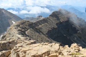
Description: this and the Mount Timpanogos Trail on the Aspen Grove side of the loop are the most popular accesses to the Timpanogos summit. The distances are roughly equal, and many believe the Timpooneke Trail to be the more scenic, partly since it switchbacks less and thus walks you through more terrain.
You'll pass periodic small, enchanting waterfalls (bring a water filter so you don't have to lug so much water), and moose and mountain goat sightings are common. They may appear tame, but they're not, so give them a wide berth.
Distance: 14.5 miles out and back.
Elevation gain: 4,668'
Steepness: not too steep for most of the way, but sustained, so consider this a difficult trail.
Notable Features: meadows, waterfalls, cliffs, wild animals, and abundant wildflowers for much of the year.
Amenities: pit toilet at trailhead, and a sort of make-shift toilet just north and up the hill from the Emerald Lake hut.
Fees: pay the entrance canyon fee if you'll use any of the amenities.
When to go: hikers often begin hiking Timp by June or July, but you can expect to cross some dangerous snowfields even into August, so be careful! One of the most popular departure times is about 1:00 a.m. in order to reach the summit by sunrise.
Directions: drive up American Fork Canyon, keep right at the Tibble Fork turn off, pass the Pine Hollow parking lot, then take a sharp right immediately after Lindemere picnic area. Drive up that road a quarter mile and park.
Photos:
Mountains, lakes and other features accessed:
Connecting & cross trails: drive past the trailhead and follow the dirt road all the way around the north side of the mountain to Sagebrush Flats. High clearance vehicle recommended. Road open seasonally.
Keep right from the parking lot (if you go down and cross a river, you're heading toward Salamander Flats and other trails).
A faint trial to Bomber Peak cuts north from the upper meadow, and you'll join the Aspen Grove Trail either just before the shoulder or slightly sooner if you take the south trail toward Emerald Lake in the upper meadow.
Download GPX: